Get digitally reproduced photos from each decade, often beginning in the 1930’s and continuing to present day….
Learn moreEDR® Environmental Data Packages
Access the industry’s best data and workflow technology
EDR Environmental Data Packages help environmental professionals perform property due diligence with efficiency and ease.
Order Now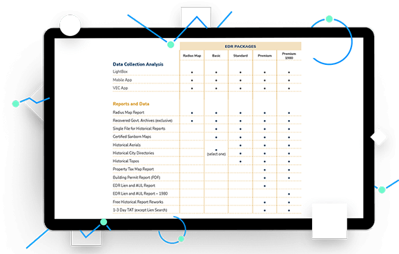
Key benefits
Choose the right package for your scope of work
Three specialty service packages: Basic, Standard, and EDR Premium.
EDR Basic Package
Access the info needed for ASTM E1528 Transaction Screens, RSRAs, and other low-level due diligence on LightBox, making drawing sitemaps and figures faster.
EDR Standard Package
Use data, content, and technology to review large amounts of information for ASTM E1527 Phase I ESAs and gain access to the VEC app.
EDR Premium Package
Conduct equity deals, complete portfolio projects, and navigate tight turnaround times for ASTM E1527 Phase I ESAs. Enjoy LightBox, the VEC App, Recovered Government Archives, a City Directory, and historical aerial photos.
| Basic | Standard | Premium | |
| Data Collection & Analysis | |||
| EDR LIGHTBOX® Viewer | |||
| VEC App | |||
| Basic | Standard | Premium | |
| Reports & Data | |||
| Radius Map Report | |||
| Certified SANBORN® Maps | |||
| Historical Aerials | |||
| Historical City Directories | Select One | ||
| Historical Topographic Maps | |||
| Tax Map Report | |||
| EDR® Lien & AUL Report | |||
| Free Historical Report Reworks | |||
| 1-3 Day Turnaround (Excludes Lien) | |||
Are you an EDR® customer and you want to acquire a package?
Review the EDR® packages
With your EDR Basic, Standard and Premium Packages, you will receive the most trusted government records and historical sources, along with cutting-edge workflow tools. Each EDR package includes EDR LIGHTBOX® Viewer for data review and analysis.
EDR Basic Package
Access the data, content, and workflow tools you need to conduct due diligence projects with speed and confidence. EDR provides the best records review in the industry along with comprehensive historical research options. EDR LIGHTBOX® Viewer makes property analysis and field data collection efficient, effective and fun.
What it’s used for
The Basic Package provides just that, the basic information needed for ASTM E1528 Transaction Screens, RSRAs, and other low-level due diligence. Like all of our packages, it can be experienced through EDR LIGHTBOX® Viewer, which makes reviewing information and drawing site maps and figures faster and more effective.
Includes
Current data
EDR® Radius Map Report with:
- The most trusted data in the industry
- GEOCHECK® physical settings data
- High Risk Historical Records
- Recovered Government Archives
Historical information
SANBORN® Maps
Your Choice of one other Historical Source
Workflow
EDR LIGHTBOX® Viewer
EDR® Standard Package
Our most popular combination of data, content and workflow for Phase I ESAs. This report is the standard in the industry for completing E1527-21 Phase Is and Phase I updates.
What it’s used for
The Standard Package is our most popular package, relied upon by environmental professionals for thousands of ASTM E1527 Phase I ESAs each year. The data, content and technology provided help EPs meet the EPA’s All Appropriate Inquiries rule. The Standard Package now includes the VEC App, to help you screen out properties for vapor encroachment risk quickly and effectively.
Includes
Data
EDR® Radius Map Report with:
- The most trusted data in the industry
- GEOCHECK® physical settings data
- High Risk Historical Records
- Recovered Government Archives
Content
Workflow
- EDR LIGHTBOX® Viewer
- VEC App
EDR® Premium Package
Want to take all of the guess work out of compliance with ASTM E1527-21 and EPA’s All Appropriate Inquiries Rule? The EDR® Premium Package fits your needs by providing a search for AULs and Environmental Liens. We also provide the additional value of upgraded delivery speed on data and content.
What it’s used for
The EDR® Premium Package is commonly used for ASTM E1527-21 Phase I ESAs, especially those conducted for equity deals, portfolio projects, high-value deals and tight turnaround times.
Convenience
- 1-3 day turnaround time on all components except for AUL & Lien Search
- Free reworks on standard historical sources
Includes
Data
EDR® Radius Map Report with:
- The most trusted data in the industry
- GEOCHECK® physical settings data
- High Risk Historical Records
- Recovered Government Archives
Content
- Certified SANBORN MAP®
- Historical Aerial Photos
- City Directories
- Historical Topographic Maps with QUADMATCH®
- Tax Map Report
- Building Permit Report
- EDR® Lien & AUL Report
Workflow
- EDR LIGHTBOX® Data Viewer
- VEC App
Connected Data
Boundaries
Building Footprints
Building footprints are geospatial boundaries that provide the outline of a building drawn along the exterior walls.
Environmental
Flood Risks
Data includes, but is not limited to, 100-year and 500-year flood zones. Canadian Flood maps provide flood extents and depths for multiple return periods, covering river, surface and coastal flooding.
Environmental
Historical Imagery and Content
Collection of historical content including SANBORN® Maps, Historical Aerial Photography, Historical City Directories, Historical Topographic Maps, Environmental Liens and AULs, and Historical Title.
Environmental
Known Incidents
Incidents identified by regulatory agencies indicating known or suspected environmental releases, contamination, or spills associated with hazardous materials, petroleum, or other products.
Environmental
Other Environmental Content
Content valuable for evaluating environmental issues, including historical gas station and dry cleaners, PFAS, water wells, oil and gas wells, radon, wetlands, topography, endangered species, registered historic sites, and more.
Environmental
Permitted Facilities
Facilities registered with regulatory agencies for operations such as hazardous waste management, landfills, underground and above ground storage tanks, and other activities associated with potential environmental concern.
Recommended Insights
Environmental Due Diligence

USEPA Issues Expected Rule Designating PFAS as CERCLA Hazardous Substance
What It Means for Environmental Due Diligence of Commercial Real Estate The U.S. Environmental Protection Agency (EPA) announced the pending…
Data
The Changing Landscape of Data Center Zoning
As the exponential growth of digital businesses and AI continues to surge, the landscape of data centers is shifting. New…
Environmental Due Diligence

LightBox helps California Forever accomplish analysis for large-scale planning project with diverse datasets
“I’d recommend LightBox for any project that demands accuracy, versatility, and efficiency. They played a pivotal role in the success…
Have questions? Want a demo? Let’s chat.
Fill out the form below and a member of our Sales Team will contact you shortly.