Get digitally reproduced photos from each decade, often beginning in the 1930’s and continuing to present day….
Learn moreEDR Radius Map with GEOCHECK®
The most comprehensive search of government records in the industry
Thousands of environmental consultants trust EDR® Radius Map Reports to meet and exceed the search requirements laid out in ASTM E1527-21 and EPA’s All Appropriate Inquiry Rule. Used for Phase I ESAs, Transaction Screens, Desktop Reviews, RSRAs and other scopes of work every day, it taps into over 2,000 continuously updated sources.
Request A Demo Order Now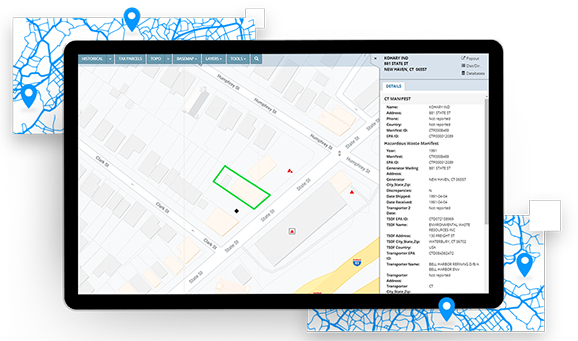
The most current and dependable data
EDR®’s team of data analysts maintains relationships with government agencies, continually updating over 2,000 federal, state, tribal, local and proprietary sources. Our update process meets and exceeds the requirements of ASTM E1527-21. Data currency is just one reason that the EDR® Radius Map Report the most comprehensive in the industry
Access proprietary, curated datasets
EDR®’s exclusive High-Risk Historical Records database ensures you never miss a historic gas station, dry cleaner or manufactured gas plant.
Gain access to even more data
Get the most current and dependable data available. Meet requirements with quick data updates thanks to relationships with government agencies.
Integration with other data resources
Integration with the LightBox data viewer allows the EDR® Radius Map Report data to be viewed and combined with other important data sets and layers, creating important insights, and allowing for fast, accurate review.
A powerful search of environmental records
A powerful search of environmental records on your property and the surrounding area is a critical first step in comprehensive environmental due diligence.
Here is why more than 200,000 commercial real estate transactions rely on EDR®’s Radius Map each year:
- EDR® searches over 1,600 environmental databases, including hundreds of state, city and tribal sources not searched by the competition.
- All EDR® Radius Map Reports now include LightBox, a revolutionary workflow tool for reviewing environmental records.
The most current and dependable data
EDR®’s team of data analysts maintains relationships with government agencies and new sources of data are updated quickly.
Our update process meets and exceeds the requirements of ASTM E1527.
Data currency is just one reason the EDR® Radius Map Report is the most comprehensive in the industry.
Connected Data
Boundaries
Building Footprints
Building footprints are geospatial boundaries that provide the outline of a building drawn along the exterior walls.
Environmental
Historical Imagery and Content
Collection of historical content including SANBORN® Maps, Historical Aerial Photography, Historical City Directories, Historical Topographic Maps, Environmental Liens and AULs, and Historical Title.
Boundaries
Parcel Boundaries
Nationwide parcel boundaries with 300+ property and tax attributes to help you make more confident decisions. Covers 3,100+ U.S. counties including territories, with over 150 million parcels with polygon geometry that is completely normalized.
Have questions? Want a demo? Let’s chat.
Fill out the form below and a member of our Sales Team will contact you shortly.
Recommended Insights
Environmental Due Diligence

USEPA Issues Expected Rule Designating PFAS as CERCLA Hazardous Substance
What It Means for Environmental Due Diligence of Commercial Real Estate The U.S. Environmental Protection Agency (EPA) announced the pending…
Data
The Changing Landscape of Data Center Zoning
As the exponential growth of digital businesses and AI continues to surge, the landscape of data centers is shifting. New…
Environmental Due Diligence

LightBox helps California Forever accomplish analysis for large-scale planning project with diverse datasets
“I’d recommend LightBox for any project that demands accuracy, versatility, and efficiency. They played a pivotal role in the success…